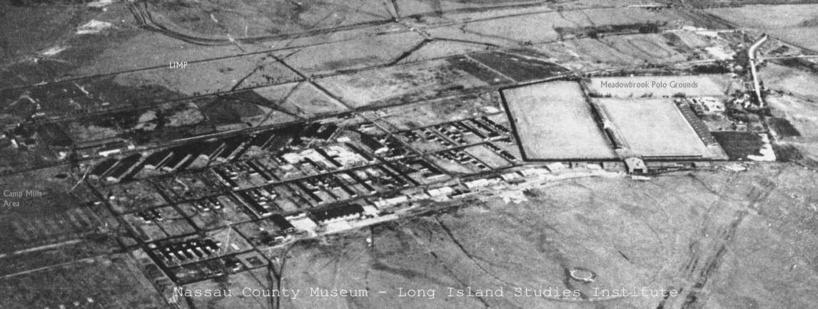
- The quadrangle bounded by Miller, Duncan, Davis and Hazelhurst Avenues of the present period (1998), was not
bisected by Selfridge Avenue. Selfridge Avenue was a realignment of the original main entrance. The original main
gate was approximately 50 feet East of the present LIRR / Selfridge Avenue crossing. Halfway through the present
quadrangle, an east/west road ran from the east end, back to the present day West Avenue. Nothing remains of this
road (Ohio?). However in 1999 there is still evidence of its existence. The quadrangle, or parade ground, was a
creation of the reconstruction of Mitchel Field. The original base headquarters was just Southwest of the intersection
of Hazelhurst and Miller avenues.
- The red brick buildings do not exist. This includes barracks and single family military homes. They will begin
to appear during the reconstruction of Mitchel Field. By 1932, they will be evident and more will be added in following
years.
- The Central Line "Trestle to Nowhere" has a road running under it. This road allowed access to the
Meadowbrook Club. This road continued southwest across the field in a less well defined manner. The two predecessor
intrusions of the Central Line rail are visible, but the present day Railroad Avenue Line does not yet exist. It
will be constructed in 1932.
- In 1928, there was no concrete storage silo. It would appear that the 1932 panoramic photo was taken from
a very large storage tank or tower.
- To the southwest of this tower is a grassy area containing rectangular blotches. These blotches are regular
in size and spacing. These are remnants of buildings and activity from Camp Mills. While some accounts of Camp
Mills indicate that it ran to Oak street, it did not. Oak Street is actually a refurbished and extended Avenue
E from Camp Mills. The 1918 United States Geological Survey(USGS) shows that Camp Mills abutted Mitchel Field.
There is no indication of an Oak Street. Using the composite 1918 and 1955 surveys of the military bases, shows
that Camp Mills ran to just west of the present day (1998) West Road. This places these buildings and activity,
within the confines of Camp Mills. These "scars" are remnants of Camp Mills activity from ten years earlier.
Sources:
1932 Panoramic photo of Mitchel Field. Photo 2865 G B Rogers Jr. National Photo and News Service. San Antonio,
Texas. Nassau County Museum - Long Island Studies Institute.
1928 photo number 9469. Uniondale, Mitchel Field northeast aerial view. Nassau County Museum - Long Island Studies
Institute.
United States. Geological survey - Camp Mills Quadrant 1918, Nassau County Museum, Hofstra Long Island Studies
Institute.
United States Geological survey - Mitchel Field Quadrant 1955, Nassau County Museum, Hofstra Long Island Studies
Institute.
Composite Survey Overlay of Military base boundaries, created from the two preceding USGS surveys. V. Fitzgerald,
10/97.
Field observations.
V Fitzgerald 3/27/98- updated / corrected and added to new site 1/01/2000.

